Thursday 29 January 2015

Exploring Portugal: Aveiro

It was mid-October and 24°C (75°F), so what better time to visit Aveiro, Portugal's very own Venice? Having located the train station the previous week, I at least had a starting point. Arriving at the station I discovered that I had timed it perfectly for the next train to Porto, which connected rather comfortably with the train to Aveiro. Stepping off the train at Aveiro, I was met by the deepest blue skies you can imagine. White buildings, partially-covered in azulejos glistened in the sun, cafes spilled onto the streets and horizons vanished into a sunny mist...

Like many cities on the Iberian peninsula, Aveiro was established by the Romans, who called it Alavarium et Salinas (literally "a gathering place of birds and salt"). The name reflects the city's main industries of sea-fishing and salt-production, which have been connected to the region for centuries. Long after the Romans had gone, the name remained, evidence of which can be found in the 10th century will of Mumadona Dias, Countess of Portugal (r. 920-968), who bequeathed her lands in "Alavario et Salinas" to Guimarães Monastery.

In 1472, the town celebrated the arrival of Joana, Princess of Portugal (1452-1490), daughter of King Afonso V (r. 1438-1481). Having turned down marriage proposals from three heirs to different European thrones, Joana joined Mosteiro de Jesus (the Convent of Jesus) against her father's wishes. Three inexplicable events in her life, and even death, led to her beatification. First, a star shone brightly for several days before she arrived in Aveiro. Then, in 1490, all the flowers on the trees in the cloister wilted and fell off as her coffin went by. Finally, in 1626, when her tomb was opened, her body was found to be perfectly preserved. Now known as Santa Joana Princesa (Saint Joana the Princess), the anniversary of her death, 12th May, has become the Day of the City of Aveiro. On that day, a procession with an image of the Princess Saint and her relics (pieces of hair, a belt and some clothing), makes its way through the city.

The so-called "Venice of Portugal"

Billed as being "the Venice of Portugal", I had high hopes for Aveiro. Truth be told, aside from a couple of canals and some gondola-like boats, known as barcos moliceiros, there is little to link the two cities. Nonetheless, the first impressions were good when I caught sight of an art installation in the form of silver-and-black life-size cow.

Modern art that appealed to me

Outside, I was struck by the beauty of the station itself. Built between 1861 and 1864, the station is decorated with azulejosblue-and-white tin-glazed ceramic tiles that were introduced into Iberia by the Moors.

The azulejo covered train station

On leaving the tiled train station, I walked down Avenida de Doutor Lourenço Peixinho, swung a right and ended up at Canal do Côjo, from where it was a short walk to Praça Humberto Delgado and Canal Central. Lined with beautiful buildings, I would later get a moliceiro from here to take a trip along the city's waterways.

With their half-moon shape, high bow and large tillers, moliceiros look quite similar to Venetian gondolas. In fact, they are quite different from their Italian cousins. For a start, with a length of 15 metres (49 feet), moliceiros are longer than the 11-metre-long (36 foot) gondolas. They are also decorated with brighter colours and more inventive designs. Finally, their original function also differs. While gondolas have always been used for transportation, moliceiros were used to collect moliço (submerged aquatic vegetation), hence their name. Today, the moliceiros have been given a new lease of life are being used primarily for tourism.

The bridge at Praça Humberto Delgado, which separates the two canals

 
Brightly coloured moliceiros


Colourful prows of the moliceiros
 

One of the many beautiful buildings


Palm-lined walkway beside Canal Central

Quite by chance I came across Mercado do Peixe (Fish Market). However, the closed market was of little interest to me, for behind it, something had caught my eyea row of brightly-coloured houses on Cais dos Botirões reflected into the water. I was mesmerised, and to this day when I think of Aveiro, that's the image that comes to mind...

Picture perfect


Houses on Cais dos Botirões, which links Canal de San Roque with Mercado do Peixe

Having done some wandering and stopped off for lunch, I wanted to take a canal boat ride so I made my way back to Canal Central, bought a ticket for €5 (approx. £4/US$7) and climbed aboard. The 45-minute trip took me down Canal Central, into Canal das Pirâmides, under a bridge painted with seagulls, into Canal de San Roque then back again and onto Canal do Côjo.
 
Painted seagulls in flight


The peaceful Canal de San Roque


The wooden Ponte dos Carcavelos

 
Still waters

Even though I hadn't been to Venice when I visited Aveiro, I was a little dubious about "the Venice of Portugal" tag. Having since visited the former, I have to say that it really isn't possible to compare the two – Aveiro is nothing like Venice whatsoever. However, when taken on its own merits, Aveiro is a beautiful city and one that's well worth visiting.

Monday 26 January 2015

Exploring Portugal: Tenões

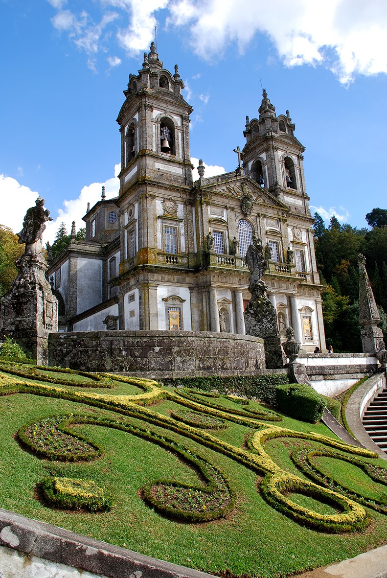
Two weeks in to my first academic year as a teacher and I decided to treat myself to a day trip, and top of my list was Tenões. What do you mean you've never heard of it?! Truth be told, I doubt anyone except the inhabitants would know where it was were it not for Santuário Bom Jesús do Monte (The Shrine of Good Jesus of the Mountain), a hilltop Catholic pilgrimage site and one of Portugal's most visited churches.

Since antiquity, hilltops have been places of worship in Europe, and it is likely that this particular hilltop was one such place. However, it wasn't until 1373 that a chapel first appeared on the hill. The chapel was later rebuilt in the 15th and 16th centuries. And in 1629, a pilgrimage church dedicated to Bom Jesús was built.

The church with the iconic zig-zag Baroque staircase in front

The current Sanctuary dates from 1722 when it was commissioned by Rodrigo de Moura Teles, the then-Archbishop of Braga (t. 1704-1728), whose coat of arms can be seen over the gateway at the bottom of the stairs. Under his direction two segments of the famous zigzag Baroque stairway were built. At the top of these was a Baroque church designed by the architect Manuel Pinto Vilalobos.

Some time later, around 1781, Gaspar de Bragança, the new Archbishop of Braga (t. 1758-1789) had the church demolished to make way for a third segment of stairs, also in a zigzag pattern, and a new church. Started in 1784 and built by Carlos Amarante, the new church was one of the first neoclassical style churches in Portugal. It was completed and consecrated in 1834.

The 18th century neoclassical church


View of Braga from the gardens

Without doubt, the most impressive part of the Sanctuary is the Via Sacra do Bom Jesús (The Sacred Way). A Baroque staircase that took 89 years to build, it rises several hundred metres.
 
Traditionally pilgrims climbed the 116-metre long (381 feet) staircase on their knees while contemplating the Stations of the Cross, which have been reconstructed with life-size statues. After this comes Escadaria dos Cinco Sentidos (Stairway of the Five Senses), each one represented by a different fountain, and then Escadaria das Três Virtudes (Stairway of the Three Virtues), which has chapels and fountains symbolising faith, hope and charity. Together these stairways represent the spiritual journey that believers must take in order to accede to salvation.

One of the many statues
 

Aesthetically-pleasing lines


The fountain representing charity


The view from further down the staircase
 
Somewhat unsurprisingly, I didn't climb the steps on my knees. Instead, I took the water-powered funicular. Built in 1882, the funicular linked the city of Braga to the hill. It was the first funicular to be built in the Iberian peninsula and it's still in use today. Having ascended by funicular, I opted to walk down the stairs – although again, not on my knees – and, when I turned around, I was rewarded by some fantastic views...
 
The 'Sacred Way' in all its glory

Thursday 22 January 2015

Exploring Portugal: Porto #1

I left Vietnam in mid-August and set about looking for work in Europe again and, more specifically, Spain. But instead, I landed a job in Portugal. I flew to Porto ahead of the contract and spent five days just soaking up everything the city had to offer...

Located along the Douro river estuary in the northwest of the country, Porto is Portugal's second-largest city. Though occupation of the area can be traced back to 275 BC and the time of the Celts, Porto as we know it today dates from the 4th century when it was known as Portus Cale under the Romans. In 711 AD, the city fell into the hands of the Moors, who remained there until 868 when King Afonso III of Asturias (r. 866-910) sent a vassal to reclaim it. Portus Cale was later referred to as Portucale, which is the origin for the modern name of Portugal.

The first thing visitors to Porto will see is the city's UNESCO World Heritage protected ribeira (riverfront), which marks the edge of the historic centre. To get the best views, you need to cross the river to Vila Nova de Gaia. I did just that and found it hard to tear myself away...

View of Porto from across the River Douro


Boats on the River Douro


Kitten looking over the river

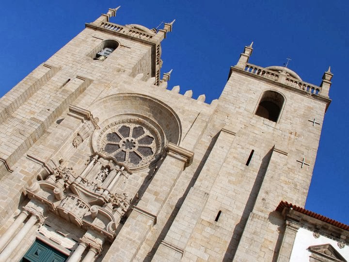
The cathedral, Sé do Porto, is not just one of the city's oldest monuments but also one of the most important Romanesque buildings in the country. Built in 1110 under the patronage of Bishop Hugo, it was completed in the 13th century.

In 1387, it saw the marriage of King João I of Portugal (r. 1385-1433) and the English princess, Philippa of Lancaster (daughter of John of Gaunt, 1st Duke of Lancaster, and sister of King Henry IV). At the same time, the Anglo-Portuguese alliance – originally signed in 1373 between King Edward III of England and King Ferdinand and Queen Eleanor of Portugal – was renewed with the Treaty of Windsor, which is the oldest diplomatic alliance in the world that is still in force today.
 
The cathedral

 
The façade

Portugal's second city it may be, but I was surprised and pleased to discover that Porto is anything but city-like. A stone's throw from the cathedral, I came across a curious arrangement of brightly-coloured pots in the street. Seeing something so 'country' made me smile, and of course I had to stop and get a picture.

In lieu of a front garden

One of my favourite sights was that of Câmara Municipal do Porto (City Hall). Built in 1920, it's made of granite and marble and its design was influenced by municipal architecture of Flanders and France. In keeping with its grandeur, it's located in the heart of the city on the imposing Avenida dos Aliados, a sloping boulevard lined with palatial buildings, most of which are hotels or main branches of the country's major banks.

City Hall


Close-up of the 70 metre-high clock tower

Another landmark is Torre dos Clérigos, the bell-tower of the Igreja dos Clérigos (Church of the Clergymen) and one of the city's most iconic sights, especially if you can catch the tram going by. Built by an Italian architect, construction began in 1732 and was completed around 1750. The 75.6m-high tower was a later addition, which was built between 1754 and 1763. Not far from the tower is Casa Oriental, the most-photographed shop in the city.

Statue of António Ferreira Gomes, Bishop of Porto (1952-1982) with Torre dos Clérigos in the background


Torre dos Clérigos with an iconic Porto tram


Helping it to remain the most-photographed shop in the city


Close-up of produce

This next photo is a pretty poor shot, but I just LOVE the story behind it. On the left is Igreja das Carmelitas. Part of a former 17th century convent, it has a simple, classical façade and a bell tower. On the right is Igreja do Carmo, a Baroque creation dating from the 18th century. The law at the time stipulated that no two churches could share a wall (in this case to hinder amorous liaisons between Carmelitas nuns and the Carmo monks) so a house was built between them. At barely 1 metre wide, it is the narrowest house in Portugal, and was actually inhabited until the 1980s! I can't imagine how claustrophobic that must have been!

Officially the narrowest house in Portugal

There is far more to see in Porto than the few things I have picked out but, having lived nearby for almost a year, only my very favourites could make the cut. However, no whistlestop tour would be complete without a (slightly blurry) night shot taken on the ribeira with the iconic Ponte Dom Luis I in the background. Looking at these photos, I can't help but feel nostalgic for my first proper home abroad...

View of Vila Nova de Gaia taken from the Ribeira

Monday 19 January 2015

Postcards from... Hòa Bình

When my teaching contract ended, I had one week in which to sightsee before heading back to the UK. First up was a three-day trip to Mai Châu, then a two-day trip to Hạ Long Bay, and finally a day trip with Ethnic Travel to the Hòa Bình province.

The driver picked us up outside our hotel at around 09:00 and then we were on our way. It didn't take long for the incessant noise of central Hà Nội to be left behind us. We gazed out of the window open-mouthed as the bulging streets gave way to open countryside – something I'd missed in my three months in the capital.

Our destination was the Hòa Bình province and, more specifically, Sông Đà (the Black River). Keen to see one last sight in Vietnam, I had picked the trip out of a catalogue, mainly because the pictures looked nice. I was not disappointed. It was every bit as stunning in reality as the pictures had led me to believe...

Mist over the Black River


Sheer perfection


What lies beneath...


A wooden shack and fishing trap

The boat dropped us off and left our guide to take us on a 5 km hike along mountainous tracks and paths used by the locals. The scenery was utterly breathtaking and to this day, I've never seen anything more beautiful than the Vietnamese countryside.

Goodbye boat


Starting our hike


Solitude


Peace and quiet

 
Another wooden shack and fishing trap

At the end of our hike, we walked down a steep slope towards the river to find the boat waiting for us. In our absence, the boat owners had prepared a feast of fish, vegetables, rice and meat. They barely touched the food themselves though, preferring to sit in a huddle watching us – three obvious foreigners – try and figure out what certain offerings contained and how to go about eating some things.

After lunch, we sat and talked while they slept. Then, the boat took us slowly down river where our driver was waiting to take us back to the noise and chaos of Hà Nội...

Thursday 15 January 2015

Postcards from... Hạ Long Bay

As both a UNESCO World Heritage Site and one of the New Seven Natural Wonders of the World, it's no wonder that Hạ Long Bay (which translates as "descending dragon bay") is high on people's 'must-see' lists.

Situated in the Gulf of Tonkin, Hạ Long Bay comprises some 1,600 huge limestone islands, which have been eroded over 20 million years. Some are hollow and home to enormous caves, one of the most well-known being Sung Sôt (Surprise Cave) on Bo Hòn Island. Some have amazing viewpoints, while others have beaches, although I believe these are man-made. At least the one I went to was.

We were bussed to Bai Cháy Tourist Wharf where we stood on a narrow ledge and waited impatiently for one of the rickety-looking boats to take us out to our cruising boat. The queue for boats was immense and, if I remember correctly, we stood there for quite a while.
 
The dirty wharf
 
Having survived my rickety boat ride through some very questionable water, I was pleasantly surprised by the style and cleanliness of the boat that I'd be calling home for the next two days. We were given some refreshments and then shown to our rooms. I dumped my stuff and went to grab a prime spot on the sun deck...
 
The sun deck

 
Entering Hạ Long Bay


One of a pair of carved dragons on the boat

And then we set sail, leaving the noisy, smelly, oily wharf behind. There were 'oohs' and 'aahs' as we caught sight of the karst formations for the first time. I must have taken hundreds of them, but thanks to losing my computer to someone who shall remain nameless, I now only have the few I'd uploaded to Facebook. They're far from the best shots I've ever taken, but they do at least give you some idea of what I experienced.

The first of many karst formations


Getting closer

After about an hour and a half on-board, we made our first stop. The boat docked close to Bo Hòn Island. We were taken to shore in a small boat, rather similar to the one we'd used at the wharf. From there it was a steep climb to Sung Sôt (Surprise Cave). Without a tripod, it was too dark in the cave to get any decent shots, but the views across the Bay more than made up for the lack of interior pictures.

Looking back at the boat... just to make sure it was still there


Another boat

 
Inside the cave


Tourists at the viewpoint


View across the Bay

Back on the boat and we continued on our journey, heading for Ti Tốp Island. Once ashore, half the group rushed to sit on the rather unimpressive man-made beach. I failed to see the appeal, preferring to climb the 427 steps to the summit (I didn't realise there were quite so many!). Having huffed and puffed up the seemingly never-ending steps, I finally reached the top and was rewarded with amazing views of misty karst formations...

Another view of the boat


The disappointing man-made beach
 

Proving that the best things come to those who climb...


Back on the boat as evening draws in

It seems so long ago now that I can't remember where the boat docked for the night. I do remember being slightly disappointed when I woke up and realised that I was heading back to Hà Nội that day. I would have loved to have stayed longer, but doing so would mean not being able to take my final tour – a visit to Hòa Bình. So, as we made our way back to the wharf, I gazed out to sea, trying to capture every last view...
 
Leaving the Bay


One of the carved figureheads

If I ever make it back to Vietnam, a longer trip to Hạ Long Bay is definitely on the cards. I barely even scratched the surface with my one-night tour.